


An earthquake measuring 6.8 magnitude has hit northeast India, near its border with Myanmar and Bangladesh, the US Geological Survey (USGS) has said.
The quake hit at 04:35 local time (23:05 GMT Sunday) about 29km (18 miles) northwest of Imphal, the capital of Manipur state, according to USGS.
Strong tremors have been felt across the region. 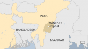
Our reporter in Dhaka says many people were seen fleeing their homes in Bangladesh.
USGS issued a yellow alert for casualties and damage, with a 35% likelihood of between one and 10 deaths from the tremor.
The earthquake was originally reported to have measured 6.8 magnitude.
The region has a history of powerful earthquakes caused by the northward collision of the Indian and Eurasian plates. They are moving towards each other at a rate of 4-5cm per year.
In 2005, a magnitude 7.6 quake in Pakistan-administered Kashmir left more than 75,000 people dead.
In April 2015, Nepal suffered its worst earthquake on record with 9,000 people killed and about 900,000 homes damaged or destroyed.